
Nandi Kund Trek : The majestic Himalayan Mountains in India attract both domestic and international mountain trekkers seeking the thrill of trekking amidst snow-clad glaciers, verdant meadows, crystal-clear rivers, and breathtaking scenery. The Nandikund Trek is among these adventures. What sets it apart is the opportunity for trekkers to explore heritage sites, temples, and monuments steeped in Hindu mythology along the route, adding an extra layer of cultural richness to the journey.

The starting point to the nandi kund trek is ransi. Picturesque journey through the mountainous terrain en route to Ransi along the renowned pilgrimage path of Madhyamaheshwar. The drive promises an intriguing experience, showcasing the diverse hues of Uttarakhand’s Himalayan landscape.
How To Reach Ransi Starting Point To Nandi Kund Trek
Nearest Airport: The nearest airport to ransi is Jolly Grant Airport, Dehradun, Uttrakhand
Nearest Railway Station: The nearest railway station to ransi is Rishikesh, Uttrakhand
By Road Hubs: Devprayag, Srinagar, Rudrapraya, Guptkashi, Ukhimath
From Airport: Nearest Airpot is Jolly Grant Airport, Dehradoon from Delhi or other cities, your option is to head to Rishikesh which is the nearest hub for buses and shared jeeps. Rishikesh is about 1.5 hours journey from Dehradoon and vehicles are frequently available. From Rishikesh ISBT or taxi stand, you get buses or jeeps to Rudraprayag, Gopeshwar or Ukhimath. From Ukhimath, you get jeeps till Ransi.
From Railway Station: For railways options, then Rishikesh should be your last point. Head to Rishikesh ISBT or taxi stand from where you get buses or jeeps to Rudraprayag, Gopeshwar or Ukhimath. From Ukhimath, you get jeeps till Ransi.
By Bus: You may also chose to reach Rishikesh by bus from Delhi. Frequent bus services are available frequently for Rishikesh from Kashmiri Gate ISBT. Volvos are available too. Busses can be booked online on http://utc.uk.gov.in/. Bus services to Ukhimath are available from Rishikesh ISBT.
Some More Help: Shared cabs are the best options to reach roadhead in Uttrakhand for any trek. If you are in a group, it helps sharing a cab. Total time taken ranges from 6 – 8 hours.
Distance to nandi kund trek starting point (Ransi) from various location
Dehradun to Rudraprayag – 190 kms
Rishikesh to Rudraprayag – 139 kms
Haridwar to Rudraprayag – 165 kms
Devprayag to Rudraprayag – 68 kms
Rudraprayag to Ukhimath – 37 kms
Ukhimath to Ransi- 21 kms
Day-1 : Ransi to Bantoli
From Ransi (2100m) to Bantoli (2700m), via Gaundhar (2850m), it takes approximately 4 to 5 hours covering a distance of 8 kilometers.
Today marks the beginning of our Nandi Kund – Ghiya Vinayak Pass Trek. We embark on a picturesque journey from Ransi to Bantoli, where the captivating scenery unfolds before us. Along the trek route, we are immersed in the rustic charm and religious life of the high-altitude villages of Uttarakhand. As a popular pilgrimage route, the trail is vibrant, adorned with a myriad of colors and bustling with life.
The trek is generally moderate, with occasional steep sections. We have ample opportunities to pause for lunch and snacks along the way to Bantoli. Near Bantoli, we encounter Gaundhar, a significant point where the Madhyamaheshwar Ganga and Markanda Ganga. Option to stay in homestays or set up our small tents. You can continue your jorney towards Madhyameshwar.
Day – 2 : Bantoli to Madhymeshwar
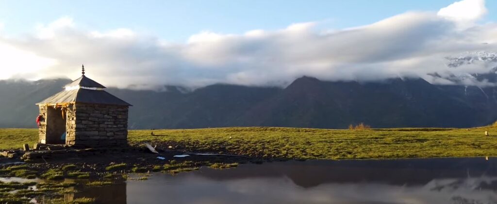
From Bantoli (2700m) to Madhyameshwar (3500m), via Nanu Chatti (2720m) and Kun Chatti (2780m), the trek takes approximately 4 to 5 hours covering a distance of 8 kilometers. You can spend the night in Madhyameshwar (3500m), with accommodation options including tents or lodging in Madhyamaheshwar.
On the second day of our trek to Nandi Kund and Ghiya Vinayak Pass, we continue our journey towards Madhyamaheshwar, one of the Panch Kedars and a revered pilgrimage site for Hindus. After passing Nanu Chatti early in the trek, we proceed through Maikhamba and Kun Chatti before embarking on a roughly 3-hour walk to reach the sacred shrine of Madhyamaheshwar.
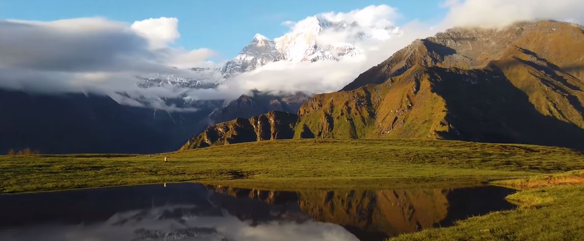
Following lunch, we undertake an acclimatization walk to Buda Madhyamaheshwar. If we’re fortunate, we may catch a glimpse of Chowkhambha reflected in a small water body near Buda Madhyamaheshwar.
Day – 3 : Madhyamaheshwar to Kachni Dhar
From Madhyamaheshwar (3500m) to Kachni Dhar (4400m), the trek takes approximately 5 to 6 hours covering a distance of 9 kilometers.
The journey to Nandi Kund undergoes a significant transformation, both in terms of the challenges of the ascent and the solitude of the path.
After awakening to a beautiful morning at the sacred site of Madhyamaheshwar, we prepare ourselves for the day’s trek. This leg of the journey entails a steep and continuous climb towards Kachni Khal, often identified by two large rocks forming a gateway.
Following a strenuous ascent of approximately 4 to 5 hours, we reach the summit of Kachni Khal. Here, the trail diverges, with one path leading left towards Kedarnath, another to Panpatia, and the route to Nandi Kund branching off to the right.
Day – 4 : Kachni Dhar to Pandavsera
From Kachni Dhar (4400m) to Pandavsera (4100m), the trek takes approximately 5 to 6 hours covering a distance of 9 kilometers.
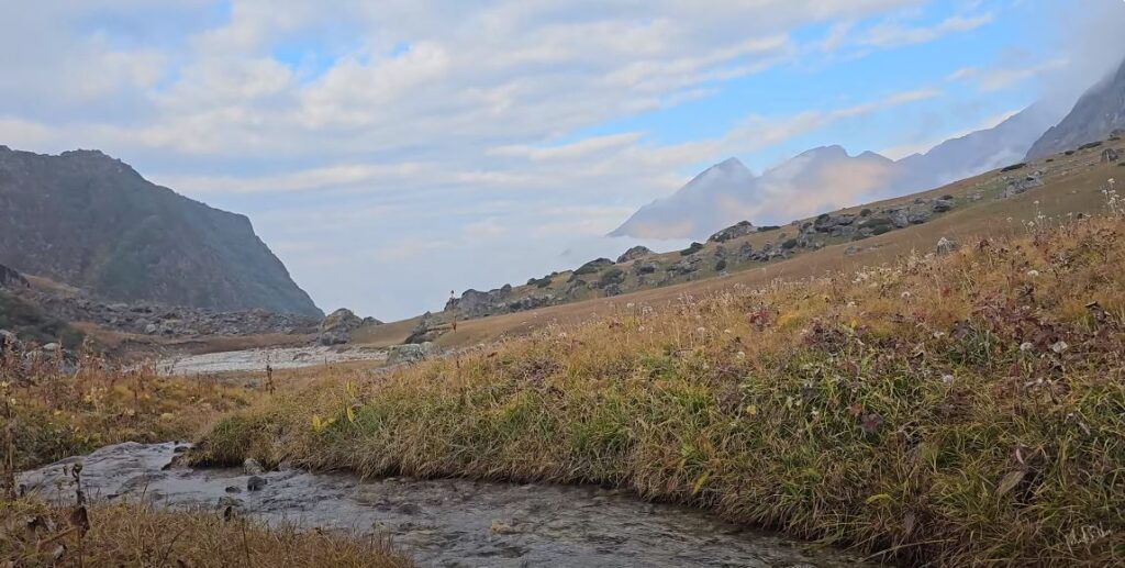
Today’s trek takes us away from any traces of civilization as we follow an unmarked shepherd’s trail to reach Pandavsera. A knowledgeable local guide is essential for navigating this terrain effectively. We trek through bushes, cross the Madhyamaheshwar stream multiple times, and encounter several small waterfalls before arriving at a flat meadow, identified as Pandavsera.
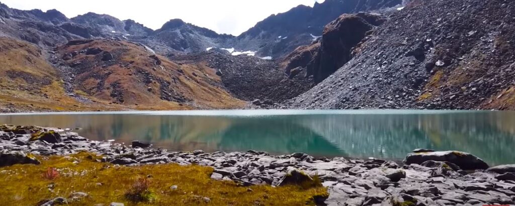
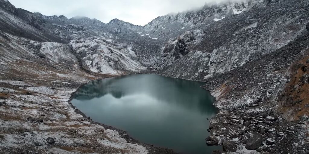
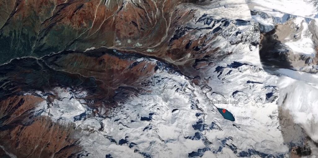
Day – 5 : Pandavsera to Nandi Kund
From Pandavsera (4100m) to Nandi Kund (4800m), the trek takes approximately 3 hours covering a distance of 6 kilometers.
The path from Pandavsera to Nandi Kund traces the course of the small stream known as Madhyamaheshwar Nala, which flows from Nandi Kund. The ascent is gradual but occasionally steep, with the rugged terrain posing its own set of obstacles. We navigate multiple crossings of the Madhyamaheshwar Nala before embarking on a steep climb for about an hour, eventually reaching the tranquil Nandi Kund.
Route Map to Nandi Kund Trek
- Ransi to Bantoli– 8 Kilometers (4-5 Hours)
- Bantoli to Madhyameshwar – 8 Kilometers (4-5 Hours)
- Madhyamaheshwar to Kachni Dhar – 9 Kilometers (5-6 Hours)
- Kachni Dhar to Pandavsera – 9 Kilometers (5-6 Hours)
- Pandavsera to Nandi Kund – 6 Kilometers (3-4 Hours)
Frequently Ask Question:
The optimal time for this trek is from May to June, extending into the early days of July before the onset of the monsoon. Following the monsoon season, the period between September and October provides another ideal window for the trek. During the pre-monsoon season, the landscape is adorned with lush green grasslands and countless tiny wildflowers. In the autumn months of September, October, and November, the winds gradually dry up the terrain, causing the green grass to transition to a brown hue while offering stable weather conditions for clearer views.
The temperature along this trek can range from -5 degrees Celsius to 18 degrees Celsius at higher altitudes, depending on the time of year. The starting and ending points of the route tend to be warmer, with temperatures possibly reaching up to 25 degrees Celsius during the summer months.
This is a complete camping trek, with no signs of civilization along the trail once we depart from the Madhyamaheshwar temple until we reach the village of Urgum. While accommodation in local homestays is available at the starting and ending points to experience local life, the trek itself involves full camping. Toilet facilities in the homestays will be basic wet toilets with Eastern-style seats, while on the trek, we will use cat-style dry toilets. We’ll carry a toilet tent and seat for comfort and hygiene, ensuring proper waste management to minimize ecological impact.
Also read : Thini top trek – Exploring the Hidden Beauty with Mesmerizing Views